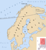
Scandinavian Peninsula
 |
|---|
| This article is part of the Scandinavia series |
| Geography |
|
| Viking Age |
|
| Political entities |
|
| History of Scandinavia |
| Other |
|
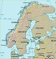
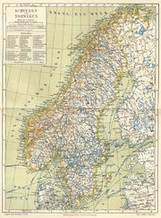
The Scandinavian Peninsula is a geographic region in northern Europe, consisting of Norway, Sweden and part of northern Finland. The name of the peninsula is derived from the term Scandinavia, the name of Denmark, Norway and Sweden, which is in turn derived from Scania, a region at the southernmost extremity of the peninsula that was formerly part of Denmark (being the ancestral home of the Danes) and is now part of Sweden. The derived term (from Scandinavia) Scandinavian also refers to the North Germanic peoples speaking Scandinavian languages[1][2][3][4]. The Scandinavian Peninsula is the largest peninsula in Europe.
Contents |
Geography
The Scandinavian Peninsula is the largest peninsula in Europe. It is approximately 1,850 kilometers (1,150 miles) long with a width varying approximately 370–805 km (230-500 mi).
The Scandinavian mountain range generally defines the borders between Norway and Sweden. The peninsula is bordered by several bodies of water including:
- the Baltic Sea (including the Gulf of Bothnia) to the east, with the autonomous Åland islands between Sweden[5] and Finland, and Gotland.
- the North Sea (including the Kattegat and Skagerrak) to the west and southwest
- the Norwegian Sea to the west
- the Barents Sea to the north
Its highest elevation was Glittertinden in Norway at 2,470 m (8,104 ft) above sea level, but since the glacier at its summit partially melted , the highest elevation is at 2,469 m (8,101 ft) at Galdhøpiggen, also in Norway. These mountains also house the largest glacier on mainland Europe, Jostedalsbreen. About one quarter of the peninsula lies north of the Arctic Circle, with the northernmost point at Cape Nordkyn. The climate across the peninsula varies from tundra (Köppen: ET) and subarctic (Dfc) in the north, with cool marine west coast climate (Cfc) in northwestern coastal areas reaching just north of Lofoten, to humid continental (Dfb) in the central portion, and to marine west coast (Cfb) in the south and southwest.[6] The region is rich in timber, iron and copper with the best farmland in southern Sweden. Large petroleum and natural-gas deposits have been found off Norway's coast in the North Sea and the Atlantic Ocean.
Much of the population is concentrated in the southern part of the peninsula; Stockholm and Gothenburg, both in Sweden, and Oslo in Norway are the largest cities.[7]
Geology
The Scandinavian Peninsula occupies part of the Baltic Shield, a stable and large crust segment formed of very old, crystalline metamorphic rocks. Most of the soil covering this substrate was scraped by glaciers during continental glaciation, especially in the northern part, where the shield is nearest the surface. As a consequence of this scouring, the elevation and the climate, a very small percentage of land is arable (3% in Norway).[8] The glaciers also deepened river valleys, which were invaded by the sea when the ice melted, creating the famous fjords. In the south the glaciers deposited many sediments, configuring a very chaotic landscape.[9]
Although the Baltic Shield is largely stable and resistant to the influences of other neighboring tectonic formations, the weight of nearly four kilometers of ice sheet caused the terrain to sink down. When the ice sheet disappeared, the shield rose again, a tendency that continues to this day at a rate of about 1 meter per century.[9] Conversely, the southern part has tended to sink down to compensate, causing flooding of the Low Countries and Denmark.
The crystalline substrate and absence of soil exposes mineral deposits of metals, such as iron, copper, nickel, zinc, silver and gold.
People
The first recorded human presence in the southern area of the peninsula and Denmark dates from 12,000 years ago.[10] As the ice sheets from the glaciation retreated, the climate allowed a tundra biome that attracted reindeer hunters. The climate warmed up gradually, favoring the growth of evergreen trees first, and then deciduous forest which brought animals like aurochs. Groups of hunters-fishers-gatherers started to inhabit the area since the Mesolithic (8200 BC), up to the advent of agriculture in the Neolithic (3200 BC).
The northern and central part of the peninsula is partially inhabited by the Sami, often referred to as "Lapps" or "Laplanders". In the earliest recorded periods they occupied the arctic and subarctic regions as well as the central part of the peninsula as far south as Dalarna, Sweden. They speak the Sami language, a non-Indo-European language of the Finno-Ugric family, which is related to Finnish and Estonian. The other inhabitants of the peninsula, according to ninth century records, were the Norwegians on the west coast of Norway, the Danes in what is now southern and western Sweden and southeastern Norway, the Svear in the region around Mälaren as well as a large portion of the present day eastern seacoast of Sweden and the Geats in Västergötland and Östergötland. These peoples spoke closely related dialects of an Indo-European language, Old Norse. Although political boundaries have shifted, these peoples still are the dominant populations in the peninsula in the early 21st century.[11]
Political development
- Main article: Union between Sweden and Norway
Although the Nordic countries look back on more than 1000 years of history as distinct political entities, the international boundaries came late and emerged gradually. It was not until the middle of 17th century that Sweden secured an outlet on the Kattegat and control of the south Baltic coast. The Swedish and Norwegian boundaries were finally agreed to and marked out in 1751. The Finnish and Norwegian border on the peninsula was established after extensive negotiation in 1809, and the common Norwegian-Russian districts were not partitioned until 1826. Even then the borders were still fluid, with Finland gaining access to the Barents Sea in 1920, but ceding this territory to Russia in 1944.[12]
Denmark, Sweden and Russia dominated political relations within the Scandinavian Peninsula for centuries, with Iceland, Finland and Norway only gaining full independence in the 20th century.
See also
- Fennoscandia
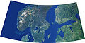 Part of Scandinavia and the Baltic region |
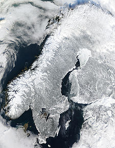
Scandinavian Peninsula in winter (February 19, 2003) |
References
- ↑ Haugen, Einar (1976). The Scandinavian Languages: An Introduction to Their History. Cambridge, Mass: Harvard University Press, 1976.
- ↑ Helle, Knut (2003). "Introduction". The Cambridge History of Scandinavia. Ed. E. I. Kouri et al. Cambridge University Press, 2003. ISBN 0-521-47299-7. p. XXII. "The name Scandinavia was used by classical authors in the first centuries of the Christian era to identify Skåne and the mainland further north which they believed to be an island."
- ↑ Olwig, Kenneth R. "Introduction: The Nature of Cultural Heritage, and the Culture of Natural Heritage—Northern Perspectives on a Contested Patrimony". International Journal of Heritage Studies, Vol. 11, No. 1, March 2005, p. 3: The very name 'Scandinavia' is of cultural origin, since it derives from the Scanians or Scandians (the Latinised spelling of Skåninger), a people who long ago lent their name to all of Scandinavia, perhaps because they lived centrally, at the southern tip of the peninsula."
- ↑ Østergård, Uffe (1997). "The Geopolitics of Nordic Identity – From Composite States to Nation States". The Cultural Construction of Norden. Øystein Sørensen and Bo Stråth (eds.), Oslo: Scandinavian University Press 1997, 25-71.
- ↑ Nordic FAQ Geography of Sweden
- ↑ Glossary of American climate terminology in terms of Köppens classification
- ↑ "Scandinavia". FactMonster.com. http://www.factmonster.com/ce6/world/A0843871.html. Retrieved 2004-03-21.
- ↑ Hobbs, Joseph J. and Salter, Christopher L.Essentials Of World Regional Geography,p. 108.Thomson Brooks/Cole.2005.ISBN 0-534-46600-1
- ↑ 9.0 9.1 Ostergren, Robert C., Rice, John G. The Europeans. Guilford Press. 2004.ISBN 0-89862-272-7
- ↑ Tilley, Christopher Y. Ethnography of the Neolithic: Early Prehistoric Societies in Southern Scandinavia, p. 9, Cambridge University Press. 2003. ISBN 0-521-56821-8
- ↑ Sawyer, Bridget and Peter (1993). Medieval Scandinavia: from conversion to Reformation, circa 800-1500. ISBN 0816617384.
- ↑ Sømme, Axel (Ed.) (1961). The Geography of Norden. Oslo: Den Norske nasjonalkommittee for geographi. ISBN none.